 Live Music Archive
 Librivox Free Audio
 Metropolitan Museum
 Cleveland Museum of Art
 Internet Arcade
 Console Living Room
 Books to Borrow
 Open Library
 TV News
 Understanding 9/11
tv Mosaic World News LINKTV November 15, 2012 11:30am-12:00pm PST
11:30 am

annenberg media ♪ captioning sponsored by annenberg/cpb narrator: north america is comprised of canada and the united states.
11:31 am

these two highly-aanced and comparatively wealthy cotries are home to an extremely urbanid and mobile population. in the u.s., many urban areas are characterized by diverse cultures, which create a rich ethnic mosaic. oufocus is boston, massachuse, part of a megalopolis located on the northeastern seaboa othe iteds. macaciopulio part of a megalopolis locahave taken root in older seainner-city neighborhoods. in recent decades, these neighborhoods deteriorated, with a downward spiral in infrastructure, services and opportunities. bunow stons bouncing back. with a downward spiral we'll see how relative location to the central business district, or cbd, is important to the development of these neighborhoods-- how so much can ride on their being part
11:32 am

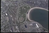
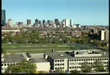
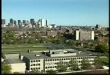
of federally-funded enterprise zones and how geographic information systems, or gis, can be used in addressing some difficult urban economic and social issues. boston, massachusetts. once a great port, it's now a world leader in high tech, higher education, bmedicine and finance. but like most u.s. cities, boston lost many jobs and middle-class residents to the suburbs. it's a regional problem-- part of the widening gap between the wealthiest and the poorest americans. this disparity has glaring spatial symptoms. ( rap music playing from car stereo )
11:33 am

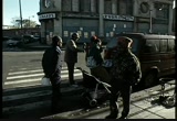
behind e incity neighborhoods ll of unemployed and underemployed residents. in the heart of the roxbury neighborhood is dudley square, still the regional hub for the city bus line, once, only downtown ston had more shoppers. today, it is rundown, according to developer joyce stanley. stanley: dudley's been an area that's been neglected for a long time by the city, by a lot of banks and the state. d what we want is something to be le to develop sof e buildings, d the rgngsant is something e in ouareao develop narrator: the hope is that large restored buildings might attract new employers to the area. it's a gamble boston needs to make using someone else's money. they desperately need jobs to combat poverty.
11:34 am
it's 1994, and the cy has just enter a competition. but unlike this friendly street game, the stakes for boston are high, and the clock is ticking. cities across the country are vying for new federal grants for something called an "empowerment zone"-- a special area of the worst poverty. f spearhead boston's forts,. e yor enlisted geographer linda haar. with the community to establish our empowerment zone plan,k i sat back and started to think about boston from the perspective of a geographer, which is my training, and i've looked at boston along spatial lines. narrator: to help do that, haar's team uses a geographic iormation sysm
11:35 am
map relative verty levelsfor . unfortunately, there are too many poor neighborhoods that qualify. there are many ways to draw the empowermt zone boundary that will decide who can and cannot receive the employment training, developmenmoneand jobs. busome of e choices stand out. haar: you can really define who lives in what neighborhood, and where are the neighborhoods th are living in poverty. and unfortunately, they happen to have a very strong relationship. narrator: but they're not all classic minority neighborhoods. marty nee is a leader from south boston, on the harr, where most residents are white irish-americans. maybe the face of poverty in boston is not just black; maybe it's not just hispanic; maybe there's a broader face of poverty that we need to look at.
11:36 am

woman: one of the reasons for that, too, is... narrator: the census maps bear him out, and today, nee joins leaders from other neighborhoods at a meeting called by linda haar. the goal: to review a draft proposal to the federal government. it looked like... narrator: joyce stanley presses her case for dudley square and adjacent grove hall. grove hall has more social service agencies than any other community, dudley also. narrator: the historical geography of boston's diverse neighborhoods is full of conflict. but the competing leaders know they can win only by uniting and drawing a politically- inclusive map. so parts of south boston join roxbury, chinatown and other areas in the empowerment zone proposal. but therare other factors besides race and poverty. the proposal takes advtage of south boston's location relative to the city's key transportation infrastructure:
11:37 am
the harbor, the interstate highways and new tunnel to the airport. adjacent neighborhoods also contain underutilized industrial space. accordg to some experts, new enterprise will succeed only if it exploits fundamental geographic advantages. commerce in roxbury, for instance, should capitalize onlose psical connections to the central business district. here, proximity can partially compensate for population with low worker skills. east's t hopeful that their proposal integrates the best economic, political d urban geography, east's t the boston team meets one last ptime before submission. what we have been able tos to incorporate all of the important points that people ha made. narrator: they submit the proposal and begin the waiting game.
11:38 am

six months later, the winners are annoced, and boston receives a $47 million second prize. ( young men cheering ) narrator: though less than hoped for, the money will fund the highest priorities. six years later, woman:whoastnaator: inouth federal grantseafood ocessand low-interest loans to build on city land in the empowerment zone. a key incentive is a tax credit for each resident hired from the zone. in dudley square, the bus station has received a facelift. the remodeled fairfield center has welcedundreds of governmenemoyees. nearby the square, these orchard park affordable housing units in adjacent grove hall,
11:39 am

a large chain constructs a new supermarket. the city offered them incentives to move into neighborhoods they had once ignored. the hope is to bring greater convenience and competitive prices, while anchoring this small shopping center. an intangible result of empowermt zone funding is more cultural and psychological. neigorod and ethnic pride is part of the strategy to promote self-sufficiency and growth. it's a spirit you can feel in places like the popular la cocina restaurant at merengue. this project is like a dream come true. narrator: hector piña is part of the sizable latino community here, and with feder loans and grants, la cocina will expand from 22 seats into this adjacent space for 90. most of the contractors are local, so what we did was, we tried to recycle the money within the community.
11:40 am

narrator: in 1999, as the first empowerment zone funds start to really pay off, ston gets more great news. they are awarded the full $100 million first prize the u.s. government, ong wi4 otr u.s.ies. and to put information in the database... narrator: now the emphasis is less on buildings and more on human development, li teaching enh as a second language and jotraining classes and morelike this one.lopment, america watches to see the impact on the urban landscape. boston, like other u.s. cities experienced a decline in many of its innermost neighborhoods. often the poorer, culturally- diverse populations living there lack access to resources such as high-quality education or job opportunities. buin an efrt to revitali boston, weaw how city anrs used geographic information systems, or gis, to analyze
11:41 am
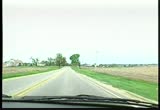
economic and demographic data in mapping an empowerment zone. we saw how relative location to the central business district proving their residents links to transportation and jobs. as cities across america seek to reenergize their urban cores, geography can provide the tools and concepts for successful urban planning efforts. in north america, growing cities are being transformed as more and more people choose to live and work far from the old urban centers. such is the case in chicago, illinois, in the midwestern section of the united states. t as delopment here expands outward, it must compete withctive farming communities on the edges of this metropolitan area.
11:42 am
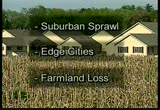
in north american cities like chicago, automobiles, extensive highway systems and communication networks have accelerated suburban sprawl and made possible a new kind of urban area. "edge cities" e full-fledged employment "subcenters" far from the central city. but there may be a cost to such rapid land use change: farmland loss. productive farmland becomes a nonrenewable resource, lost forer, when it is used for housing, commercial or industrial development. and the pace at which america's st productive farmland is being lost has alarmed some geographers. we're standing on the new edge of chicago's suburban frontier. behind me is a farm that will be gone in five years-- literally wiped out. we're seeing the black dirt
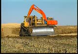
11:43 am
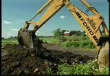
that took thousands of years to develop. what will be in its place is suburban development. narrator: but it's not nostalgia for days gone by that concerns geographer richard greene. at northern illinois university, he's studying development patterns around the chicago metropolitan area, and what worries him is the science and economics of what's being lost. green: the soil that is being removed here took 10,000 years to create. and in just a matter of a few weeks, this soil will be gone narrator: and if you don't believe it,en theask a local farmer.s. man: yeah, when i put that driveway in, i had a cat come in here, and he took black dirt out of here at wasil18s to et dp be he hit l w,itavelt mit's... dirt out of here
11:44 am

t only is it good di it'sdwhh is wwant w,itavelt mit's... dirt good soil with good drainage is what grows crops. you also have to have the climate; you also have to have the rainfall; you have to have the infrastructure. so it has everything going for it, this area does. an intense competition for the land has been raging. to see how the pressure developed, we head downtown to the center of chicago. the tallest building in north america-- the sears tower-- rises over downtown chicago. it is the trademark of this city's skyline and a symbol of urban america's vitality. but in 1992, sears fled its downtown home and moved 5,000 employees here-- 30 miles outside the city, into the cornfields. working farm communities surround the chicago area,
11:45 am

but to many, this farmland is better suited for growing something other an corn. usses reca so tirmployees, ke mrgwn now they have what they've always wanted-- a house in the country. owarommu it's a rural community. it's just... it's a feel-good kind of place to live. come in this route and... narrator: just down the road, tim edmonds is building a whole new community for people like margot brown. soon his efforts will transform this farmland into corporate office parks, a golf course and 4,600 new homes. this is, indeed, an edge city. as you look at suburbanization of america and following transportation corridors, both north and south-- whatever the geographic area happens to be-- it is, uh, an example of that. people here are commuting within the 25-to-30-mile radius.
11:46 am

um, u're not going to see too much migration into the city, but they are currently working with about a 25-mile radii, and they're looking for value and looking for, uh, lifestyle. the development is really creating a whole, new town. uh, we will have up to 5,000 residential units, roughly 400 acres of commercial office areas. we have various retail components, golf courses, school sites. so you're going to see all the elements that you would see in most hometowns. uh, they will all be in one development. narrator: one development-- building over 2,600 acres of prime farmland. pihl: sobo is fe xioumo buyangrth is put pssureo.
11:47 am

, phys lesle pihl: d you could take the money xioumo buand go fishing pssureo. and forget about the chores and the war and the droughts ey're binyoures. ey're buyi youcommunity. they're changing everything andthat you hold dear,oughts and, uh, that's... that's a very tough decision. narrator: is undergoing a post-industrial a w trenotransformation, away from its agriculture and even its urban roots. metropolitan chicago is being reformed, and its new edges are reaching out further and further into the surrounding farmland. greene: this community is very typical of the suburban fringe of chicago.
11:48 am

we are about 45 miles from downtown chicago-- downtown chicago being the largest employment center. historically, then, that... that was the core. that was where people traveled to work. the metropolitan area has since evolved and you have subcenters now-- employment subcenters. and we're about two-hours' commute from downtown chicago, whereas to the subcenters, we're as few as 15 minutes away from those subcenters. or first in these once purely residential subcenters. then businesses themselves followed their employees to this suburban fringe. in the information age, with the growth of white-collar service
11:49 am
and high-tech industries, companies no longer need the central business district to prosper. and thanks to the widespread reliance here-- as in the rest of america-- on the automobile, commuters who work in these subcenters can now move even farther away from downtown-- commuters like margot brown. each day, margot takes just 20 minutes to drive from her home in mchenry county through the rural countryside and east along interstate 90 to her job at the corporate headquarters of motorola. this electronics giant left the high taxes and congestion of downtown chicago in the early 1980s to come to the edge city of schaumburg. have followed motorola manyto the edge.esses geographer richard greene looks for patterns in both space and sequence. in the last five years housing, residential development
11:50 am

has come right up against this western road-- randall road. and typical of this type of development, what's followed is retail. up and down randall road for miles is strip mall after strip mall. and this is the latest example. where a new store has come in, you see this wide, expansive parking lot. this was once all farmland, and now what's in its place is this new shopping development. narrator: and local governments are hard-pressed to try and control the pace of change. man: somebody woke up that route 47 and 90 tied together. i mean, people have been going through here akgene forthey'rt ert hereasil o opscon in a town where mayor ed banks currently serves a population of 2,098.
11:51 am

some like it and some of them don't. bui helpt. atgoing o, ayked a p who's going to take it over? we're still going to have the traffic up and down 47. they're not going to move 47 for you people here in huntley. 's goi there.yo blessith ase'demohi we see that the buyers stuin the greater midwest, they seek going back to their roots, back to a hometown, and we can do that here, because we own so much land and we control the land use here. have you made any progress at all on talking to this farmer about getting that? yeah, there's a little resistance. really, what is the resistance? uh, six generations have lived there over the years and i think there's resistance at moving at this juncture. is he trying to hold you for more money, or does he just really want to...
11:52 am

i wish i could figure that out. i think they're tied to the land. they've been out here for generations. the likelihood of more money i don't think is a real consideration. i think he's jusinove t old rm. narrator: individual holdouts can't compete with the constant pressure for development. richard greene charts the rapidly changing land use to investigate development's impact on the area's prime farmland. the geographic information system hasoweds from t soil onseiconoiquit dfoverthe twoto rlladdresd eied uan lanuses from t soil atgrne's gis pdus ap dfoverthe twoto rlladdresd highlighting in red productive farm communities which are most threatened by encroaching development.
11:53 am
greene has also created a national map of the u.s., showing the areas that are most susceptible to farmland loss. he finds that densely-populated farming regions, like those in california and florida, are particularly threatened by suburban growth. thoumericareot angeofoi some of the best agricultural land in the world. once developed, it's almost impossible to return in the chicago area, rmers are not the only ones alarmed by the rapid growth. margot brown is concerned that traicike could soonon its way developis going to belyat t w e h littlwn of marengo.owow greo d ity of lif margot brown is concerned are gointoape
11:54 am

could soonon its way narrator: devethe irony is the threat w e to margot's quality of life greo is created by other people just like her. she and michael used to live in schaumburg, t itas toowdedo mangoanund brown: what we han mao that was space, peace and quiet, d pretty much everything i need is at my fingertips. nathamic d people want peace and quiet, along with shorter commutes and continued access to the conveniences of modern life. edmonds: everybody is convenience-driven. and we want to have everything at our fingertips. u're seeinthis migration and the eating up of these areas by development, that's undeniable. it's not that we've created it; we're taking advantage of the demand.
11:55 am

narrator: and as demand increases, john pihl is feeling closed in. pihl: we see pressure every dayhe. we have housing, residential housing slated for right up to our fence line right next to the farm. narrator: john knows farmers in the county who have sold for as much as $20,000 an acre. an offer like that could bring in $10 million for this 500-acre farm. since he now earns about $40,000 a year, e essureo sellisuildg. but for now, his concerns are holding him back. pihl: i think probably what we're mosconcerned about is thaingsre cingincrediblyast, ani hate to segs, good things get lost narrator: whether or not john continues to stay on this land, others will not resist the temptation to sell. farming is fast becoming a thing of the past in chicago's edge communities, and though local zoning regulations
11:56 am

can moderate the eff of gwth, as the search so does development's steady push down the interstate. in north america automobiles and highways have come to dominate the landscape of human settlement. along the way, they have led to an urban development pattern that is unique in the world. the highways here provide extraordinary mobility to the people who live in north america. and that mobility helps fuel rapid growth the result:ancommercials newly developed edge cities. the overall effect: lower population density. the loss of our most buproductive farmland--we sw land, that once paved over, cannot be put back to agricultul use.
11:57 am
but pursuit of the american dream-- owning a home with a spacious yard-- will continue, and with it, the continued transformation of the american landscape. captioned by media access group at wgbh access.wgbh.org


163 Views


Uploaded by TV Archive on
